DRAUGAS NEWS Lithuanian World Wide News in English
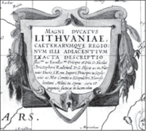
The Famous Radvila Map of the Grand Duchy of Lithuania
Some 400 years ago, an enterprising Lithuanian magnate produced the largest and most accurate representation of Lithuanian lands. His map is regarded as one of the greatest cartographic achievements of all time.
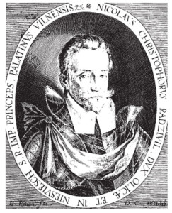
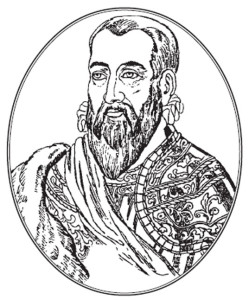
DUKE MIKALOJUS VIII KRIS- tupas Radvila (1549-1616), nicknamed “Našlaitėlis” (“the Orphan”), was one of the most important figures in Lithuanian history. He belonged to the Nesvyžius and Olika branch of the famous Radvila dynasty of magnates whose members played such an influential role in the development of Lithuanian and Polish politics, arts, and sciences. His father was Mikalojus Radvila “Juodasis” (“the Black”), Chancellor of the Grand Duchy of Lithuania and Palatine (governor) of Vilnius.
Mikalojus Kristupas studied in Germany, France, and Italy. In 1568 he participated in the war against Moscow, and in 1569 was elevated to the rank of Field Marshal. In 1579 he was made Supreme Commander of the Lithuanian army and again fought the Muscovites during 1579- 81, but had to leave military service because of poor health. In 1590 he became Palatine of Trakai, and in 1604 – Palatine of Vilnius. Although he was raised in strict Calvinist surroundings, he later became an ardent Catholic. He was also a great promoter and supporter of the arts, music, literature, and sciences.
In 1582-84, Duke Mikalojus Radvila went on a pilgrimage to the Holy Land and visited Palestine, Egypt, Syria, Crete, Greece, and other Middle Eastern countries. He wrote about his trip in the form of letters, which were published under the title Peregrination or Pilgrimage to the Holy Land in Latin (1601), German (1603), Polish (1607), and Russian (1787). The book was highly regarded because it included much historic and scientific information, including the first ever printed mention of a hippopotamus.
Around 1585, Duke Radvila began the planning of the work on a large-scale map of the Grand Duchy of Lithuania. He put a lot of effort in organizing a team of experts who would be able to perform such immense task. Among others, he hired the royal cartographer Matthias Strubicz, the Silesian. Earlier, during the reign of Stefan Bathory, Strubicz had began work on editing and reworking maps of the territories subject to the King of Poland and Grand Duke of Lithuania, particularly those of Lithuania. Maps by Mercator, the best available representation of Lithuania and Livonia at the time, were not satisfactory. The amount of data in that part of the Lithuanian-Polish Commonwealth required devotion to the work on that map exclusively, which was Strubicz’s intention.
Correspondence between Strubicz and Chancellor Jan Zamoyski, in which the cartographer asks Zamoyski for support in obtaining material relating to the Grand Duchy of Lithuania from the King, proves that work on the map was well advanced already in 1579. In a letter to the Chancellor, Strubicz wrote: “I am positive that there exists a more reliable and precise description of those Lithuanian lands, made in the times of war, without which I started my work, but am not able to complete. I would be much obliged to Your Excellency for your support to my earlier request to His Majesty the King, to lend me for a short time such description of the Grand Duchy of Lithuania.”
Strubicz’s own description of Lithuania did not meet his requirements as material for the new map. Such was probably also the case with the map for which he was asking, as in all likelihood it was the work by Stanislaw Pachlowiecki, engraved in Rome, and made on the basis of data and materials collected during the military campaigns. Although being the first example of military cartography in the Lithuanian-Polish Commonwealth, the map did not meet Strubicz’s expectations either. Therefore, the cartographer finally decided to work in cooperation with Duke Mikalojus Kristupas Radvila, hoping that the latter’s energy and spirit of enterprise may lead to the publication of a highly accurate map of the Grand Duchy of Lithuania, as planned. As the starting point for research, Strubicz began collecting his own earlier works which he had been drawing since his appointment to the Royal Chancellery in 1559.
Diligent and precise as he was, Strubicz probably was not the sole author of the map; it must have been the result of team work. However, the composition of such team would be extremely difficult to recreate today. Judging by surprisingly precise location of places where Jesuit colleges stood, it would seem that members of that Order were also involved in the work of the map. Duke Radvila, a convert from Protestantism to Catholicism, maintained close relations with the Society of Jesus; he even built a college for Jesuits in his hometown of Nesvyžius. The sciences were held in great esteem among members of that Order, so in all probability, many measurements were made with state-of-the-art instruments and based on mathematical and astronomical calculations. It is known that the outstanding Jesuit mathematician, the Englishman F. Jacob Bosgrave, was visiting Lithuania at the time when the map was being created; some sources say that he was the founder of the mathematics department at the University of Vilnius. It seems therefore probable that Bosgrave contributed to the work of the editorial team, which was perhaps headed by the Duke himself. Bosgrave could have commissioned some work to his students at the mathematics department, as he was very complimentary about them in his letters to the General of the Order, Claudius Aquaviva. Regrettably, nothing else is known about that group of young promising mathematicians.
An analysis of Radvila’s correspondence allows to assume that the Duke sought assistance in the work on the map with Lithuanian, Belorussian, and perhaps even Ukrainian magnates, and also with officials at the Court. This clever strategy allowed the enterprising Duke to make use of various influences and support to execute his ambitious task in minute detail. One of such noble assistants could have been the Palatine of Kiev, Duke Konstantinas Ostrogiškis, to whom Radvila wrote in order to collect data on the lower course of the Dnieper river.
It seems that the work on the map was completed in 1599, and Strubicz began thorough search for an engraver and a publisher of the final draft. Following is an excerpt from Strubicz’s letter to Duke Radvila, written during the former’s trip to Dantzig, Germany (today Gdansk in Poland), where he tried to publish the map and to commission the engraving with the goldsmith Jan Kolner (Kolner’s company actually existed at that time and was listed in the records of Gdansk goldsmiths of that period.) Strubicz, along with the Jesuit Rector Jan Uberus, accompanied Radvila’s sons in their journey to Gdansk. In his letter to the Duke, Strubicz wrote “… so that we could meet ‘perfectum sculptorem et expertum artificem,’ who could accept the commission and engrave that map done by Your Excellency with due care and skill here in Gdansk, we happened to find an ‘artifex’ who would undertake the work, a Joannes Kolner. He only wishes to see the drawing of the map, ready for engraving. Therefore the Rector suggests to send the material for the engraver’s inspection, as it may be God’s wish to have it made and prepared here in Gdansk. I would be infinitely grate ful if Your Excellency could let me know his mind in this respect…”
In 1604, the cartographer’s son, Samuel Strubicz sent a message from Augsburg, Germany to Duke Radvila, informing him that his ex-libris and coat of arms are ready to be placed on the map: “…[I had] an excellent sculptor engrave Your Excellency’s coat of arms on a copper plate, in order to place it on the map which is here…” However, it is unknown whether the map had been engraved in Gdansk, or in Augsburg. In his letter, Samuel Strubicz fails to give the name of the engraver whom he commissioned to engrave the Duke’s ex-libris and coat of arms. (In reality, the “coat of arms” mentioned in the letter was not that of Duke Radvila, but the emblem of the Grand Duchy of Lithuania – the Vytis.) Augsburg in those days was an important centre of cartographic and publishing business, but it is difficult to identify the engraver mentioned in Strubicz’s letter, and to determine, whether that “sculptor” also had engraved the map.
The map’s best known edition of 1613 was published by Hessel Gerritsz of Amsterdam, known for his editions of the maps of Russia. Thanks to him, a theory appeared, that only the name of the Nesvyžius engraver Tomas Makauskas should be associated with the concept of exclusive authorship of the Radvila map of Lithuania. This concept, however, seems to be more than controversial. Makauskas’ knowledge would not be sufficient for him to perform such an immense task on his own. As far as we know, Makauskas was primarily, and perhaps only the map’s engraver. However, the final draft of the map was made by an expert artist, such as was Hessel Gerritsz. This is shown by the diverse representation of the antropogeographical elements and highly original design of the final version. Undoubtedly, Makauskas made all in his might to highlight his name, and achieved this aim with the assistance of Gerritsz, whom he probably knew well. Gerritsz even speaks about Makauskas being a geographer, which does not seem probable.
Various versions of this map are found in libraries in Lithuania, Poland, and other countries, while the oldest, and only known copy, probably its second edition, is owned by the Library of the University of Uppsala in Sweden. A letter of the curator of the cathedral chapter of Warmia, Father Tomasz Treter to Duke Radvila, allows to date the first edition of the map to before 1607. The earlier mentioned letter of Samuel Strubicz, sent from Augsburg, suggests the year 1603.
A copy of the map, as a complete version of the 1613 edition was placed by Willem Janszoon Blaeu in his atlas of 1631 and published in Amsterdam. Blaeu used Gerritsz’ original plates, but designed the descriptions differently, and removed the map of the lower course of the Dnieper river, which was published separately. The map graticule’s longitude is measured from the zero meridian drawn through the Pic de Teide on Tenerife (Canary Islands). A reduced version of this map was placed in most of the significant Dutch, French, German, and English atlases of the 17th century.
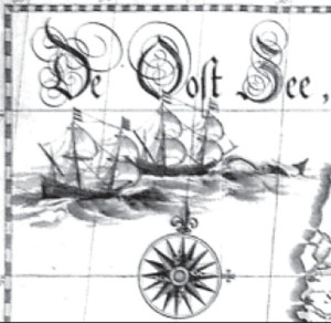
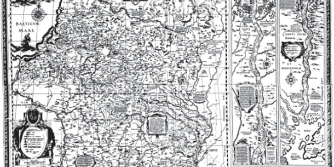
The Radvila map of the Grand Duchy of Lithuania, supplemented with a brilliant, detailed chart of the lower course of the Dnieper river and an exhaustive description in Latin about Lithuania, Vilnius, and Lithuanian customs and traditions, signed with the initials T(omas) M(akauskas), became one of the milestones in cartography of that part of Europe, leaving far behind the representations of other parts of the Commonwealth. For more than 150 years it was the sole source of information on Lithuania and neighboring areas. Even today, it surprises experts for its outstanding graphic rendering and the amount of geographical and historical data included. There are more than 1020 towns, villages, monasteries, and other localities shown within the boundaries of the Grand Duchy of Lithuania, in addition to colorful descriptions of battles and other historic events. The map is embellished with several cartouches, a compass rose, sailing ships in the Baltic Sea, and the centuries-old emblem of the Lithuanian State – the galloping Vytis.