 DRAUGAS NEWS Lithuanian World Wide News in English
Cartography (from the Greek Khartes, papyrus, and graphein, to write) is a witrecreated at a later date from his writings. We are aware of several fifteenth-century maps of Central Europe that present a topographic image of Lithuania, but they were compiled by Italian mapmakers from the data given by Ptolemy in the second century AD. The first written record of the name of Lithuania, Litua , was made in 1009 in the Quedlingburg Annals , but when did the native name for Lithuania or Lithuanians first appear on a map? To date, the earliest known mapness to world history. Early maps were hand-drawn and they began to be printed as wood engravings only by the mid-fifteenth century. During the Renaissance, copper plates were used for printing in addition to wood blocks; until the mid-nineteenth century, maps printed from copper plates were colored by hand. In our times, vastly newer technologies are used in data accumulation, design and publication of maps and atlases.
The earliest known map is a matter of debate, but we are certain that the ancient Greeks made maps from November at least the time of Anaximander in the sixth century BC.
The land where the pagan state of Lithuania later emerged was known to the ancient world. In the fourth century BC, Pytheas of Massalia, a Greek explorer, reached the Baltic area. Archaeological findings confirm trade between the Baltic peoples and Greek and Roman merchants of the classical era. In Claudius Ptolemy’s famous treatise on cartography, Geographia, there is a description of the eastern Baltic coast in which two West Baltic tribes, the Galindians and Sudovians, are mentioned. His original maps have not survived, but were recreated at a later date from his writings. We are aware of several fifteenth-century maps of Central Euro- pe that present a topographic image of Lithuania, but they were compiled by Italian mapmakers from the data given by Ptolemy in the second century AD.
The first written record of the name of Lithuania, Litua , was made in 1009 in the Quedlingburg Annals , but when did the native name for Lithuania or Lithuanians first appear on a map?
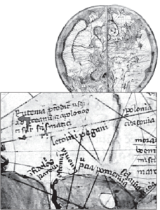
To date, the earliest known map that indicates Lithuanians is the 1321 manuscript world map ( mappa mundi ) of Pietro Vesconte, a Genoese cartographer and geographer working in Venice. The map was included in Marino Sanudo’s book Liber Secretorum Fidelium Crucis . Lithuanians are shown on the map in the Baltic Sea area as Letvini pagani , pagan Lithuanians. At that time, Lithuania was ruled by King Gediminas (1316-1341), whose title in Latin was Dei gratia Letwinorun et multorum Ruthenorum rex (“By the Grace of God King of Lithuanians and many Russians.”)
The name of Lithuania also appeared on a map in the year 1375 when a Majorcan Jewish book illuminator and clockmaker, Abraham Cresques, who described himself as being a master of maps, prepared the Catalan Atlas . In the European sec- tion of the atlas, Cresques mentions Lithuania as Litefanie paganis, pagan Lithuania.
Maps and plans were already being made in Lithuania at the time of Vytautas the Great (1350-1430). Historic sources describe negotiations held in Rome in 1421 between Pope Martin V and delegations from Lithuania, Poland and the Teutonic Order regarding their mutual borders. Historians believe these delegations relied on a map bearing the seals of the King of Poland, Jogaila, and the Grand Duke of Lithuania, Vytautas.
The first detailed cartographic view of Lithuania since antique times was made in 1450 on a map of Central Europe by the German scholar Nicolaus Cusanus. On this map, Vilnius, Kaunas, Trakai, Medininkai and Klaipėda are marked. Nine years later, the Venetian monk Fra Mauro prepared his magnificent map of the world, in which the Lithuanian lands are labeled with a Latin name, Litvania.
After the discovery of the New World by Columbus, the rulers of Lithuania needed more up-to-date and accurate maps to broaden commercial relations and better administer their realm. The golden era of Lithuanian cartography was about to begin.
Wapowski, the Father of Polish and Lithuanian Cartography
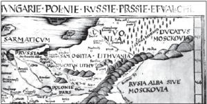
Until the first half of the sixteenth century, vast areas of Europe between the Baltic Sea and the Black Sea, including those of the Lithuanian- Polish Commonwealth, were shown by European cartographers in a schematic way, relying mostly on Ptolemy’s data. These Italian and German mapmakers provided little information consistent with contemporary geographic facts. Therefore, the entire picture of the northeastern part of Europe, far distant from the wellcharted Mediterranean Sea, was a long way from reality on Renaissance maps. Not even the renowned Turkish cartographer Piri Reis was an exception; his 1513 map of Europe in his famous work, Kitab-i Bahrrye (Book of Navigation), gave an accurate view of the Mediterranean lands only.
However, this situation would soon be changed by a Polish historian, Bernard Wapowski. He remained a close friend of the astronomer and mathematician Mikolaj Kopernik (Nicolaus Copernicus), since they studied together at Cracow University. In 1511, while in Rome, Wapowski assisted Marco Beneventano in the preparation of a map of Central Europe. In 1515, he became secretary to the Grand Duke of Lithuania, Žygimantas I (Sigismund the Old), and immediately began work on maps of “Sarmatia,” an area that now encompasses Lithuania, Poland, Belarus and Ukraine. Wapowski was a highly skilled researcher, with a talent for combining, sorting and analyzing the diverse data collected for his ambitious cartographic projects. Between 1526 and 1528, three of his maps were published in Cracow by Florian Ungler. Excellent for their time, these up-to-date maps by Wapowski—who undoubtedly had the assistance of Kopernik—were known in Italy in manuscript form before their publication . Two maps of the Russian lands by the Italian mapmakers Battista Agnese and Paolo Giovio, both dated 1525, are proof of this; the western parts of Russia on both maps are clearly based on the slightly earlier manuscript maps of Wapowski.
Over the next century, Wapowski’s maps would be the principal basis for the great cartographers of Western Europe—Olaus Magnus, Caspar Vopelius, Giacomo Gastaldi, Gerhard Mercator and Abraham Ortelius—when they mapped the territories between the German lands in the west and the state of Muscovy in the east.
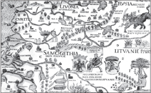
The first individual map of Lithuanian lands was drawn by the “father of modern mapmaking,” Gerhard Mercator, around 1570. Despite some inaccuracies, Mercator’s map was published in various editions of his renowned Atlas between 1595 and 1630. In addition, the Flemish cartographer gave a detailed two-page description of Lithuania on the reverse of the map. Mercator wrote the following about this easternmost country of Renaissance Europe: “This is a vast country, located near [the Duchy of] Moscow and covering that part of Russia to the east that does not belong to the Grand Duke of Moscow. […] The Grand Duchy of Lithuania is now divided into ten provinces, with the center, or capital, Vilna [Vilnius]. Local people call it Vilenski , and Germans, Wilde . ” Mercator also offered a description of the Lithuanian capital: “Vilnius is densely populated, a large and famous city, surrounded by walls with gates that are never closed. Houses are mostly wooden, low and small, without bedrooms and kitchens, not even cattle sheds, although the majority of the population have cattle and animals; the houses are scattered and built without any order, with the exception of some streets, where beautiful brick houses have been built by foreigners who frequently visit the city on business; such houses adorn the German and Castle streets [to- day’s Vokiečių and Pilies streets.] Vilnius has two royal palaces: one is large and beautiful, with many chambers on several floors, and the other with towers can be seen on the hill.”
important and accurate map of the Grand Duchy of Lithuania.
Wapowski’s grand work, which probably found no equal in the Europe of his time for its quality of information and cartographic and astronomic research, was eventually improved upon by other notable Polish Renaissance cartographers: Wacùaw Grodecki (1562), Andrzej Pograbka (1570) and Maciej Strubicz (1589). Grodecki’s map of Poland and Lithuania, “Poloniae Litvaniaeq descriptio,” had a more accurate cartographic view of Lithuania than those of Wapowski or Mercator and was included in Abraham Ortelius’s atlas Theatrum Orbis Terrarum . Thirty-one editions of the atlas were published in several languages between 1570 and Ortelius’s death in 1598.
The credit for the sixteenth century development of Polish and Lithuanian cartography, however, should go mainly to Cracow University and its alumni. Thanks to the historical, astronomical and cartographic work of Jan Dùugosz, Marcin Bylica, Wojciech Brudzewski, Jan of Gùogow, Maciej Miechowita, Bernard Wapowski and others, Renaissance Cracow brought Poland and Lithuania into the sphere of interest of world science.
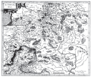
Radvila’s Map: the Greatest Renaissance Cartographic Work
At the turn of the sixteenth century, Lithuania not only gained legal status equal to the Polish Crown but also an awareness of its own historical and cultural traditions, which was reflected in the development of Lithuanian cartography. After the Union of Lublin (1569), a general sense of Lithuanian identity emerged. The Polish historian Maciej Stryjkowski was greatly responsible for the awakening of Lithuanian patriotism. The author of two works that document the history and greatness of the Lithuanian nation, his masterpiece, Kroni- ka Polska, Litewska, Zmudzka i wszystkiej Rusi (1582), was to influence the cultural milieu of Lithuania for hundreds of years.
Inspired by Stryjkowski, Duke Mikalojus Kristupas Radvila (Radziwiùù) Našlaitėlis, an ambitious Lithuanian nobleman—Voivode of Vilnius and Trakai, Grand Marshal of Lithuania, Duke of Olyka and Nesvyžius, and Prince of the Holy Roman Empire— was not satisfied with the maps of Lithuania available to him. Therefore, around 1585, he organized field cartography throughout the Grand Duchy of Lithuania. Radvila was determined to prepare a grand map, extremely accurate and of excellent design. He put a lot of effort into assembling a team of experts that would be able to complete such an immense undertaking. Among others, he hired the king’s cartographer, Maciej Strubicz; a Jesuit mathematician from England, Jacob Bosgrave; and the Catholic Bishop of Kiev, Jozef Wereszczynski to contribute to the project, which Radvila headed and financed himself.
Correspondence between Strubicz and Chancellor Jan Zamoyski, in which the cartographer asks the chancellor for help obtaining from the king materials relating to the Grand Duchy, suggests that Strubicz was the leading cartographer of the Radvila team: “I am positive that there exists a more reliable and precise description of those Lithuanian lands, made in the times of the [Livonian] war, without which I started my work, but am not able to complete. I would be much obliged to Your Excellency for your support of my earlier pledge to His Majesty the King to lend me for a short time such a description of the Grand Duchy of Lithuania.”
The diligent Strubicz was perhaps the leading authority on Radvila’s cartography team, but he was definitely not the sole author of the map. Judging by the surprisingly precise locations given Jesuit colleges, it seems that Lithuanian members of the Jesuit Order were also involved. Another assistant was the Voivode of Kiev, Konstantinas Vasilijus Ostrogiškis (Konstanty Wasyl Ostrogski), whom Radvila wrote for data about the lower course of the Dnieper River. What is certain about the preparation of this map is that many measurements were made with precise instruments and based on mathematical and astronomical calculations.
The work on this large-scale cartographic view of Lithuania was probably completed in 1599 or 1600, and Strubicz began to search for an experienced engraver and a publisher for the final draft. The first draft of the map was possibly published in Nesvyžius (present-day Nesvizh in Belarus) in 1603, but more likely in Amsterdam. This edition is mentioned in correspondence and account books, but no copy is known to survive. The earliest and only known copy of this magnificent map is from the 1613 Amsterdam edition, engraved by Hessel Gerritzs and printed by Willem Janszoon Blaeu. It is currently housed at Upsala University in Sweden. Around 150 settlements and sixty rivers are indicated on the map in the territory of present-day Lithuania alone.
Thanks to Gerritzs, a theory arose that Tomasz Makowski, an engraver under the employment of Duke Radvila, should be given exclusive authorship of this particular map. No wonder that in older literature the Radvila map was described as “map of Tomasz Makowski.” However, Makowski, who was born in Polesia, which at the time was a province of the Grand Duchy, was not a cartographer, but a graphic artist, famous for his 1600 panoramic view of Vilnius, a work that surpassed earlier panoramas of the Lithuanian capital in both its documentary precision and artistic level. He also engraved views of Kaunas, Trakai, Biržai, Nesvyžius and other cities. But he could not perform such an immense task on his ownno one could—and that is why Radvila had hired a team of experts to create the first original and accurate map of the entire Grand Duchy.
But Makowski made every effort to highlight his name, even claiming to be a geographer, and undoubtedly achieved fame with the assistance of Gerritzs, who was probably his friend. Makowski is also credited with the written description of Lithuania in the Amsterdam 1613 edition of the map. He wrote some excessive compliments about Lithuania: “The Grand Duchy of Lithuania is a very large and famous country. […] This country now has plenty of cities, towns and villages, of which the best known is Vilnius, capital of the entire state, a famous and very large city, together with suburbs stretching for two German miles, established at the confluence of the Vilija [Neris] and the Vilnia [Vilnelė]. The one which gave the name to the city is small, but the other is bigger and navigable; flowing down for fourteen miles, it joins the Nemunas at Kaunas. The city itself has a great many splendid buildings, both public and private. There are few wooden houses now, and they are placed in more distant and remote places and suburbs. There are also two castles, not so much strong as beautiful […] In addition, the city has many magnificent Roman and Russian rite churches, plus a Jesuit academy known for various sciences.”
The Radvila map was a milestone in European cartography, leaving far behind the presentation of other regions of Europe. For almost two centuries, it was the sole source of information on Lithuania and neighboring areas and was copied, remade and republished in various atlases. It has brought renown to Lithuania for five centuries. Experts are still surprised at its outstanding graphic and cartographic content and geographic accuracy.
Other Notable Maps
Seventeenth and eighteenth century cartography included not only maps of countries, but also maps of estates, plans and views of cities, and plans of battles and sieges.
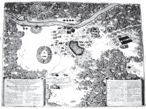
Fryderyk Getkant was a notable military cartographer, whom his friend Kazimieras Semenavičius, the Lithuanian rocketry pioneer, called “the Polish Archimedes.” Getkant drew city plans and once, in disguise, he secretly drew the plan of Pillau (today Baltrysk), seized by the Swedes. His manuscript atlas contains a magnificent plan of Vilnius’s fortifications made in 1648.
Another military mapmaker of that era was the Lithuanian captain of artillery and military engineer Kristupas Eigirdas, who drew battlefield plans during the Cossack Uprising (1648- 1657). They were issued by the renowned Frankfurt publisher Matthäus Merian.
Regarding maps of estates, there is an excellent map of the Duchy of Biržai, the Radvila family’s extensive private estate in northern Lithuania, made by the Lithuanian cartographer and architect Juozas Narunavičius Naronskis in 1645.
Especially significant for the history of Lithuanian cartography is the French mapmaker Nicolas Sanson d’Abbeville’s map of the entire territory of the Grand Duchy published on five large separate sheets between 1659 and 1665.
Lithuanian cartography of the sixteenth and seventeenth centuries can be credited with creating a prototype for the plans of the city of Moscow, published numerous times in the West. Their progenitor is the plan of Moscow drawn in the years 1606- 1608 by Szymon Jedraszewicz Smietanski, a townsman from Nesvyžius. Tomasz Makowski engraved this detailed plan showing pictures of all the most important buildings in the Russian capital. The metropolitan plans of Moscow published in Western Europe after 1610 were, for the most part, simplified copies of the plan made by Smietanski.
It is worth mentioning that one of the earliest and most important maps of Russia was also created by a Lithuanian cartographer, Antanas Vydas (Antonius Wied), who was born in Danzig, but lived and worked in Vilnius. Around 1555, he published a detailed map of the Russian territories, with the east oriented towards the top. It is regarded as the first modern map of Russia. At the lower right corner of the map, there is this notation: “Ex[ecutid] Wilda Litvaniae April Ano. 1555.” Wilda or Wilde (wild place) was the German name for Vil-nius. This map was used by Munster, Ortelius, Jenckinson and other cartographers as a source for their maps of Russia. It is believed that Vydas was also the author of the first map of Lithuania, although no copies of it have been found.
After 1613 and until the mid-eighteenth century, most maps of Lithuania were based on the masterful Radvila map. An interesting copy was made by Frederick de Wit, a Dutch cartographer, who in 1690 published his map of Lithuania with north located on the right-hand side.
Another map of Lithuania, engraved by the Jesuit priest Jonas Nepreckis (Jan Nieprzecki) in 1749, was a more accurate version of the 1613 map, correcting many deformations of the cartographic view of the Grand Duchy.
In 1772, the Italian cartographer Giovanni Antonio Rizzi Zannoni drew a map of the Polish-Lithuanian Commonwealth, “Carte de Pologne…” to a large scale. This particular map was well decorated and detailed. For the first time in the history of Lithuanian cartography, roads and many settlements were depicted with quite realistic descriptions. Zannoni’s map was popular until the early nineteenth century, and it is assumed that Napoleon used it during his invasion of Russia in 1812. Also, the French Royal Hydrographer, Rigobert Bonne, published another ex- ceptionally accurate map of Poland-Lithuania in 1787. His Atlas Encyclopedique , which was issued in several editions, was one of the most com- mercially successful atlases published during the Enlightenment. In 1791, Vilnius University initiated the systematic mapping of all the Grand Duchy’s territory. Among those who supported this ambitious project was the famous Lithuanian astronomer, mathematician and rector of Vilnius University, Martynas Počobutas. Unfortunately, this project was stopped in 1795 by the third and last partition of the Lithuanian-Polish Commonwealth. Lithuania would only appear on world maps again after 1918.
Conclusions
Extant maps of the sixteenth through eighteenth centuries prove that during that time Lithuania kept pace with the cartography of Western Europe, which was not unfamiliar to the society of major cities of the Grand Duchy, including Vilnius. Indeed, the achievements of Lithuanian cartography helped Western, as well as Muslim, cartographers update their depictions of the territories between the German lands and the Russian steppes up to the last quarter of the eighteenth century.
Today, the Vilnius University Library has the largest collection of early maps of the Grand Duchy in the country. It has over seven hundred atlases printed before the nineteenth century and more than ten thousand maps. Without a doubt, these valuable holdings are a priceless cultural heritage, containing much food for thought for those interested in the cartography, history and art of Lithuania.